Monday 24 November 2014

Ōmachi earthquake

USGS ShakeMap for the Omachi earthquake

On Saturday night a strong earthquake hit Nagano Prefecture in central Japan. The United States Geological Survey (USGS) reports the magnitude as 6.2, with Japan Meteorological Agency (JMA) suggesting 6.8. The epicenter was located 16 km NNE of Ōmachi, a city of approximately 30,000, and 24 km west of Nagano, a city of 387,000 famous for hosting the 1998 Winter Olympics. Nagano Prefecture is landlocked and highly mountainous, with 9 of the 12 highest mountains in Japan.


The Ōmachi earthquake reached a seismic intensity of 6 on the JMA scale. Seismic intensity is a measure of the degree of shaking at the earth’s surface (unlike moment magnitude and the outdated but often mentioned Richter Scale, which measure the total energy released), with 6 on the JMA scale sufficient to make it difficult to stand. The earthquake produced several other effects expected for an earthquake of this intensity - severe damage to buildings, surficial ground cracks and landslides. The earthquake was felt across a large portion of central Japan, from Osaka to Tokyo and Niigata. The earthquake was felt in Hamamatsu, the base for the QuakeRecNankai team until earlier this month. Shaking here reached 2 on the JMA scale, sufficient for most people to feel, but not enough to do any damage. Our field season in Japan finished without any of us feeling a single earthquake. There was no risk of a tsunami from the Ōmachi earthquake - these are generally associated with larger earthquakes along the subduction zones to the south and east of Japan. 

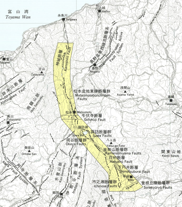
The Japan Times is reporting that the government's Earthquake Research Committee is attributing the earthquake to slip on the Kamishiro Fault, part of the Itoigawa-Shizuoka Tectonic Line (ISTL). The ISTL is a major fault system running approximately North-South across central Japan. Slip rates on the ISTL are high, averaging 10 m per thousand years, but historical seismicity has been low, with no large earthquakes recorded since AD 841 (Okamura, 2001). Trenches dug across the Kamishiro Fault in 1995 and 1996 suggest four earthquakes over the last ~7000 years, with the last probably reflecting the historically documented AD 841 earthquake (Okamura et al., 1998).


References:
  • Okumura,K., R. Imura, T. Imaizumi, M. Togo, H. Sawa, K. Mizuno, Y. Kariya, and E. Saito, 1998, Recent surface faulting events along the northern part of the Itoigawa-Shizuoka tectonic line -Trenching survey of the Kamishiro fault and east Matsumoto basin faults, central Japan. Zisin, 50, 35-51.
  • Okamura, K. 2001. Paleoseismology of the Itoigawa-Shizuoka tectonic line in central Japan. Journal of Seismology, 5, 411-431. 

Thursday 13 November 2014

Japanese animal diversity


Even though the main focus of the QuakeRecNankai project is directed towards finding geological evidence of past earthquakes and tsunami, fieldwork showed us that there is much more to see! This short overview of some of our flying, swimming, crawling and creeping companions proves so.


When crossing the waters of Lake Hamana, cormorants (Phalacrocoracidae) greeted us more than once. Cormorants are fish-eaters, diving into the water from the surface. After fishing they often go ashore to dry their plumage by spreading and flapping their wings in the sun.
Japanese cormorants at Lake Hamana, sitting (left) and drying their feather pack (right) on poles that mark the main pathway for boats in the lake.


Not only cormorants, but herons (Ardeidae) as well crossed our path several times on and around Lake Hamana, providing some beautiful and sometimes even dramatic images.

Herons, motionless (left) and in full flight (right).

While taking samples from a marshy environment along the coast of Lake Hamana, a group of sandpipers (Scolopacidaekept us company. These brown-grey shorebirds eat small invertebrates picked out of the mud or soil using their elongated beaks.
Group of sandpipers, feeding themselves on small invertebrates that are living in the coastal mud.

One of the most surprising encounters with Japanese fauna, was the one with the ‘jumping fish’ in Lake Hamana. The jumping ability of silver carps (Hypophthalmichthys molitrix) combined with their attribute of being scared easily by boat engines, causes them to leap high into the air. Moreover, observations and laboratory experiments in the past have shown that carps are extremely sensitive to impending earthquakes, picking up on minor temblors up to weeks before the main shock. For example, before the magnitude 7.6 earthquake struck Taiwan in 1999, carps were reported to batter themselves to death by repeatedly colliding their heads against the walls of their pond (Earthquake Precursors by Motoji Ikeya, http://www.eqsigns.net/aquatic_animals.html).
Jumping Asian carp, splendidly captured by Svenja... during one of many attempts (left). Shoal of carps in a park pond in Tsukuba, framed by autumnal coloured tree leaves (right).

In the category of insects, the praying mantis (Mantidae) and Japanese hornet (Vespidae) played a memorable role. Several hornets came to visit us in our office rather unexpectedly, causing some commotion among the Japanese collaborators, who were well aware of the wasps’ highly painful stings. 
Praying mantis, enjoying a walk on our survey vessel on Lake Sai (Fuji area).
Defeated (left) and still living (right) hornet in our office in the fisheries lab near Lake Hamana. A 50 yen coin serves as scale.
After being slightly alarmed by the ‘unfriendly’ appearance of the Nephila clavata or Jorō spider, we became used to its (omni)presence. Despite their large size as well as their bright colours (yellow stripes on their legs and red marks on their abdomen), these spiders are harmless and even used for commercial production of spider silk in Japan. 
Jorō spiders, guarding their webs made of, in the sun, gold-shining thread.


During a calm afternoon of coring in one of the many paddy fields surrounding Lake Hamana, a nutria or coypu (Myocastor coypus) came strolling by through one of the field-bordering channels. These ratlike mammals with their characteristic, orange teeth, are native to South America, but meanwhile colonised most of the world. They are one of the invasive species in Japan, often seen in wetland areas. 
Our friend, the nutria, splashing through the water of a drainage channel.


Despite the frequent warnings for pit vipers, hiding themselves in between grass and in puddles within rice fields, we ‘unfortunately’ never got to see one of them... 

Tuesday 11 November 2014

Evacuate

If you're on a coast adjacent to a subduction zone and you experience prolonged or intense shaking, the sensible thing to do is to evacuate in case the earthquake is followed by a tsunami. High ground provides the safest place to evacuate to, but if you're on a wide, flat coastal plain, you may not have time to reach the closest slope. Particularly in areas close to the fault, where you may only have a few minutes before the first wave hits (perhaps 5-15 minutes in the case of some of the south central Japanese coast), high ground will take too long for many people to reach. 

One solution is vertical evacuation. Particularly following the Tohoku earthquake in 2011, tsunami evacuation towers have been built in vulnerable locations along the Enshunada coast. The concept is simple - build a tall tower capable of withstanding both intense shaking and the tsunami wave and evacuate vertically in the event of an earthquake. The photos here are from the Otagawa lowlands, approximately 30km east of Lake Hamana.

Tsunami evacuation tower seen from the ground level. The top is at approximately 15m above sea level.
The view to the west from the top of the evacuation tower. The coastal plain stretches for more than 30km in this direction. QRN team members in the foreground.
The main space for evacuation. The top floor can hold 180 people and the entire structure can hold 400. Solar panels provide an electrical supply.
Yokoyama-san investigates the contents of an emergency supply box on the top of the evacuation tower.


Building retrofitted with external steps for tsunami evacuation
The concept of vertical evacuation up artificial mounds in response to extreme waves is not new. Here QuakeRecNankai team member stand in front of an artificial mound built in 1680 for evacuation during typhoons. It was last used 30 years ago.
The life-saving hill at Minato
Artificial mounds continue to be created alongside evacuation towers.
While tsunami evacuation towers and mounds are clearly essential for saving lives in vulnerable regions with flat coastal topography, in densely populated areas, the capacity of vertical evacuation structures may be insufficient and other solutions must also be found. 

Saturday 8 November 2014

Coring is not boring

Meanwhile, things have been busy and a lot of work has been done on Lake Hamana by the offshore team. About time for a new update on how everything went.

Geopulse raft strikes a pose...
Similar to our surveys on the Fuji lakes, reflection seismic profiling and lake bottom coring has been executed on Hamana-ko (ko = lake in Japanese). Due to the larger size of our survey boat, a slightly different coring setup had to be constructed, which consisted of the usual winch mechanism and, in this case, a higher elevated, over-the-side pulley. The advantage of this setup resides within the fact that heavy, full liners do not have to lifted out of the water by direct man/woman-power, saving a whole lot of efforts. 33 cores from 14 different locations were collected during 2 days of hard work, providing us with interesting study material for exploring the sedimentary infill of Lake Hamana.

Survey boat, with cabin for seismics in rainy weather and huge deck for easy coring!

New coring setup with high over-the-side pulley.
The reason why we are interested in the bottom sediments of this lake, is related to its capacity to collect deposits through time. Every year, a certain amount of sediment accumulates on the lake floor. Whenever an earthquake and/or tsunami occurs, this process of gradual sedimentation can be disrupted. Earthquakes are able to remobilise instable slope deposits, after which these move downslope rapidly in the shape of a density current (turbidity current), travelling and settling down into the deepest parts of the lake. Tsunami waves, in turn, are supposed to wash in a lot of coarser grained material (coastal dunes), organic fragments (trees and other plant), marine organisms (shells, plankton) etc. Hence, large earthquakes, often accompanied by tsunami, are supposed to have left a distinct imprint in the cored lake sediments. These event-deposits can be interpreted in terms of paleoseismics in order to improve the existing understanding of source mechanisms and recurrence patterns of earthquakes in the study area and along the Nankai Trough.

Our collection of Hamana lake cores, nicely lined up.
However, at this point of the project we can only guess what is in the liners... until they are brought back to Belgium where they will be opened. Meanwhile, our lake samples as well as the samples collected by the on-land team have left Hamana and will be shipped soon.