Showing posts with label Japan. Show all posts

Monday, 29 December 2014

Philip Garrett visits GSB

For the last full week before Christmas, the Geological Survey of Belgium, Royal Belgian Institute of Natural Sciences, played host to Dr Philip Garrett, a Japanese scholar from the University of Cambridge. Dr Garrett is a Research Associate at the Faculty of East Asian and Middle Eastern Studies, where his research in the field of medieval Japanese history focuses on land and society in central Japan. His detailed historical knowledge, particularly of sites around the Kii Peninsula, is of great interest to the QuakeRecNankai project. The Kii Peninsula lies in the centre of the coastline affected by earthquakes and tsunamis from the Nankai-Suruga subduction zone. The southern tip of the peninsula, Cape Shionomisaki, marks the hypothesised boundary between the source areas of Nankai and Tōkai earthquakes.  
 
The Kii Peninsula, south central Japan. Yellow lines indicate plate boundaries. The lakes around Mount Fuji and the area around Lake Hamana are the main targets of the QuakeRecNankai project.
The productive visit included locating and translating numerous papers in a wide range of hard-to-find Japanese publications on the documentary and geological evidence of historical earthquakes and tsunamis. We're particularly interested in how the focus of paleoseismological research has changed since 2011, when inadequate anticipation of the size of the Tōhoku earthquake and tsunami led to a rapid reevaluation by the Japanese Cabinet Office of how earthquake and tsunami hazards should be assessed. New guidelines stress the necessity of evaluating the largest possible size of earthquake and tsunami from all available lines of evidence. With some notable exceptions, the majority of this research, and of research from before 2011 has been published in Japanese only. 

Dr Garrett also led a useful and entertaining session on professional manners and Japanese etiquette for QRN collaborators from the Geological Survey, Ghent University and the University of Liège. 

Tuesday, 16 December 2014

X-ray computed tomography (CT scans)


All of our survey equipment and samples arrived in Belgium safely. Time to get the real work started! 

Before opening the cores from Lake Hamana, three-dimensional tomographic images were made with a medical CT scanner at the Ghent University Hospital (UZ Ghent). Indeed, the same device doctors use to look at bone fractures or detect other medical conditions. The X-ray CT technology is based on sending out a fan-shaped beam of computer processed X-rays from a helically revolving source. These rays become attenuated by a centrally positioned sample object (in this case, a sediment core) and collected again by a rotating array of detector cells. This setup allows to make full body scans of the objects of interest (Last & Smol, 2001). Resulting 3D images are a composite of series of 2D tomographic slices, in which every volume element (voxel) is represented by a specific shade of grey. These greyscales are a reflection of the measure in which the X-ray beam has been attenuated along its pathway and depend on the density as well as the composition of the sediment (Orsi et al., 1994). White voxels correspond to a complete attenuation of the signal, whereas black ones indicate no attenuation at all. Generally coarser grained sediment tends to attenuate the signal more severely than finer grained material. Also, every mineral generates its own characteristic attenuation, which is a function of the applied level of radiation energy.

Schematic side view and cross view of a medical CT scanner while imaging a sediment core. A rotating X-ray source continuously sends out a fan-shaped beam, which is received again by the synchronously revolving detector array. Meanwhile a motorised table gradually moves the core through the scanner, resulting in a helical scanning path. 

Within the QRN-project, CT images will be used mainly to identify depositional structures that are impossible or difficult to recognise on split surface photographs. They allow us to obtain a first impression of the content of the cores before even opening them. Moreover, processing software makes it possible to manipulate the data in order to enhance the visibility of specific features (e.g. coarse grained intercalations (tsunami deposits?), shells, rocks, laminations, cross stratification…).

Top: CT scanner at the Ghent University Hospital, illustrating the setup for X-ray core scanning on an already opened liner (not from Lake Hamana). Bottom: Example (core from Lake Kenai, Kenai Peninsula, south-central Alaska) of how resulting CT images (A) tend to look like, compared to original sediment surface pictures (B). This record is composed of an earthquake triggered event deposit or ‘turbidite’ (brown line) embedded within background laminations (light blue lines).

Timelapse of the Ghent University Hospital X-ray CT scanner in action. 


References

Last, W.M. and Smoll, J.P. (2001). Tracking environmental change using lake sediments. Volume 2: Physical and geochemical methods. Kluwer Academic Publishers. 515 pp.

Orsi, T.H., Edwards, C.M. and Anderson, A.L. (1994). X-ray computed tomography: A non-destructive method for quantitative analysis of sediment cores. Journal of Sedimentary Research 64A, 690-693.      

Monday, 24 November 2014

Ōmachi earthquake

USGS ShakeMap for the Omachi earthquake

On Saturday night a strong earthquake hit Nagano Prefecture in central Japan. The United States Geological Survey (USGS) reports the magnitude as 6.2, with Japan Meteorological Agency (JMA) suggesting 6.8. The epicenter was located 16 km NNE of Ōmachi, a city of approximately 30,000, and 24 km west of Nagano, a city of 387,000 famous for hosting the 1998 Winter Olympics. Nagano Prefecture is landlocked and highly mountainous, with 9 of the 12 highest mountains in Japan.


The Ōmachi earthquake reached a seismic intensity of 6 on the JMA scale. Seismic intensity is a measure of the degree of shaking at the earth’s surface (unlike moment magnitude and the outdated but often mentioned Richter Scale, which measure the total energy released), with 6 on the JMA scale sufficient to make it difficult to stand. The earthquake produced several other effects expected for an earthquake of this intensity - severe damage to buildings, surficial ground cracks and landslides. The earthquake was felt across a large portion of central Japan, from Osaka to Tokyo and Niigata. The earthquake was felt in Hamamatsu, the base for the QuakeRecNankai team until earlier this month. Shaking here reached 2 on the JMA scale, sufficient for most people to feel, but not enough to do any damage. Our field season in Japan finished without any of us feeling a single earthquake. There was no risk of a tsunami from the Ōmachi earthquake - these are generally associated with larger earthquakes along the subduction zones to the south and east of Japan. 

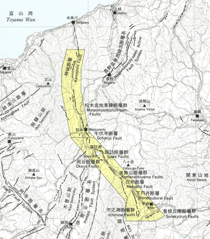
The Japan Times is reporting that the government's Earthquake Research Committee is attributing the earthquake to slip on the Kamishiro Fault, part of the Itoigawa-Shizuoka Tectonic Line (ISTL). The ISTL is a major fault system running approximately North-South across central Japan. Slip rates on the ISTL are high, averaging 10 m per thousand years, but historical seismicity has been low, with no large earthquakes recorded since AD 841 (Okamura, 2001). Trenches dug across the Kamishiro Fault in 1995 and 1996 suggest four earthquakes over the last ~7000 years, with the last probably reflecting the historically documented AD 841 earthquake (Okamura et al., 1998).


References:
  • Okumura,K., R. Imura, T. Imaizumi, M. Togo, H. Sawa, K. Mizuno, Y. Kariya, and E. Saito, 1998, Recent surface faulting events along the northern part of the Itoigawa-Shizuoka tectonic line -Trenching survey of the Kamishiro fault and east Matsumoto basin faults, central Japan. Zisin, 50, 35-51.
  • Okamura, K. 2001. Paleoseismology of the Itoigawa-Shizuoka tectonic line in central Japan. Journal of Seismology, 5, 411-431. 

Saturday, 8 November 2014

Coring is not boring

Meanwhile, things have been busy and a lot of work has been done on Lake Hamana by the offshore team. About time for a new update on how everything went.

Geopulse raft strikes a pose...
Similar to our surveys on the Fuji lakes, reflection seismic profiling and lake bottom coring has been executed on Hamana-ko (ko = lake in Japanese). Due to the larger size of our survey boat, a slightly different coring setup had to be constructed, which consisted of the usual winch mechanism and, in this case, a higher elevated, over-the-side pulley. The advantage of this setup resides within the fact that heavy, full liners do not have to lifted out of the water by direct man/woman-power, saving a whole lot of efforts. 33 cores from 14 different locations were collected during 2 days of hard work, providing us with interesting study material for exploring the sedimentary infill of Lake Hamana.

Survey boat, with cabin for seismics in rainy weather and huge deck for easy coring!

New coring setup with high over-the-side pulley.
The reason why we are interested in the bottom sediments of this lake, is related to its capacity to collect deposits through time. Every year, a certain amount of sediment accumulates on the lake floor. Whenever an earthquake and/or tsunami occurs, this process of gradual sedimentation can be disrupted. Earthquakes are able to remobilise instable slope deposits, after which these move downslope rapidly in the shape of a density current (turbidity current), travelling and settling down into the deepest parts of the lake. Tsunami waves, in turn, are supposed to wash in a lot of coarser grained material (coastal dunes), organic fragments (trees and other plant), marine organisms (shells, plankton) etc. Hence, large earthquakes, often accompanied by tsunami, are supposed to have left a distinct imprint in the cored lake sediments. These event-deposits can be interpreted in terms of paleoseismics in order to improve the existing understanding of source mechanisms and recurrence patterns of earthquakes in the study area and along the Nankai Trough.

Our collection of Hamana lake cores, nicely lined up.
However, at this point of the project we can only guess what is in the liners... until they are brought back to Belgium where they will be opened. Meanwhile, our lake samples as well as the samples collected by the on-land team have left Hamana and will be shipped soon.